


Emergency critical missions with manned and unmanned air facilities in cooperative flight (ENJAMBRE) (ITMATI-C27-2014)
The ENJAMBRE project is part of CIEN's call for Strategic Projects of the year 2014.The main objective is the development of intelligent systems for advanced control of paths for the cooperative operation between manned aircraft and RPAS (observation operations), for the characterization of the territory and for the efficiency of unloading operations for the forest fires.
The elaboration of different expert systems in the decision making is done on the basis of different type of information stored in large databases. These databases can contain information of the type of LiDAR (information of the territory, the type of fuel at the time of a fire, etc.) to information regarding the aircraft that are working at any given time in a task of extinguishing a fire.
For all this, the action to be developed by ITMATI within the ENJAMBRE project has focused on the following specific objectives:
- Generate databases to feed intelligent systems and validate their operation.
-
Having highly accurate georeferenced LiDAR type information, which allows the characterization of the territory and feed the expert system.
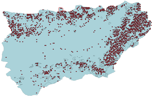
- Dots represent the National Forest IFN3 plots inventory for the characterization of the territory at the Jaen province.
Within this project thermal algorithms have been developed to estimate the perimeter, as well as the flame fronts and the fires.
Another objective of this project is to estimate the heat flow by radiation emitted by the flame front to avoid burns and pain to the human being. The flow of heat from the flame front at different distances and in all directions is represented on a map, and the brigadier will know how far he can approach to avoid pain.
Finally, the linear intensity of the fire is determined, which allows establishing the appropriate extinction criteria, taking into account the spread of fire.
An algorithm has also been developed for the calculation of escape routes for the brigades. The objective is to calculate an escape route for the evacuation of the brigades working on the ground, so that the extinction director is provided with a safe escape route to remove the brigades from the fire to the selected destination. As an example, the following illustration shows the route that the algorithm calculates to go from the position of the brigades marked with the red dot to the safe zone marked in green.
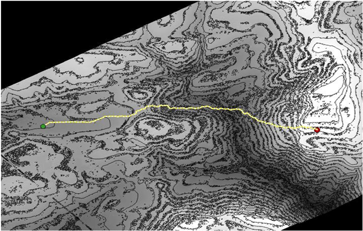
- Lower cost route between the position of the brigade (red dot) and the position of the camp or safe area (green dot).
The results of this project will contribute strongly to develop technologies to optimize the efforts dedicated to the extinction of fires and that allow to reduce the affected surface, as well as increase the security of the brigades, improve the coordination in the extinction operations, extend the time zone of action and introduce new aerial resources in the fight against major forest fires. Likewise, the investment, operation and maintenance costs of the operations can be reduced, increasing the coverage and efficiency of the service.
- Sectors: Aeronautics, Environment
- Head Researcher: Wenceslao González Manteiga
- Company: Coremain
- Duration: August 2014 - July 2018